

Emerald Pages
◆
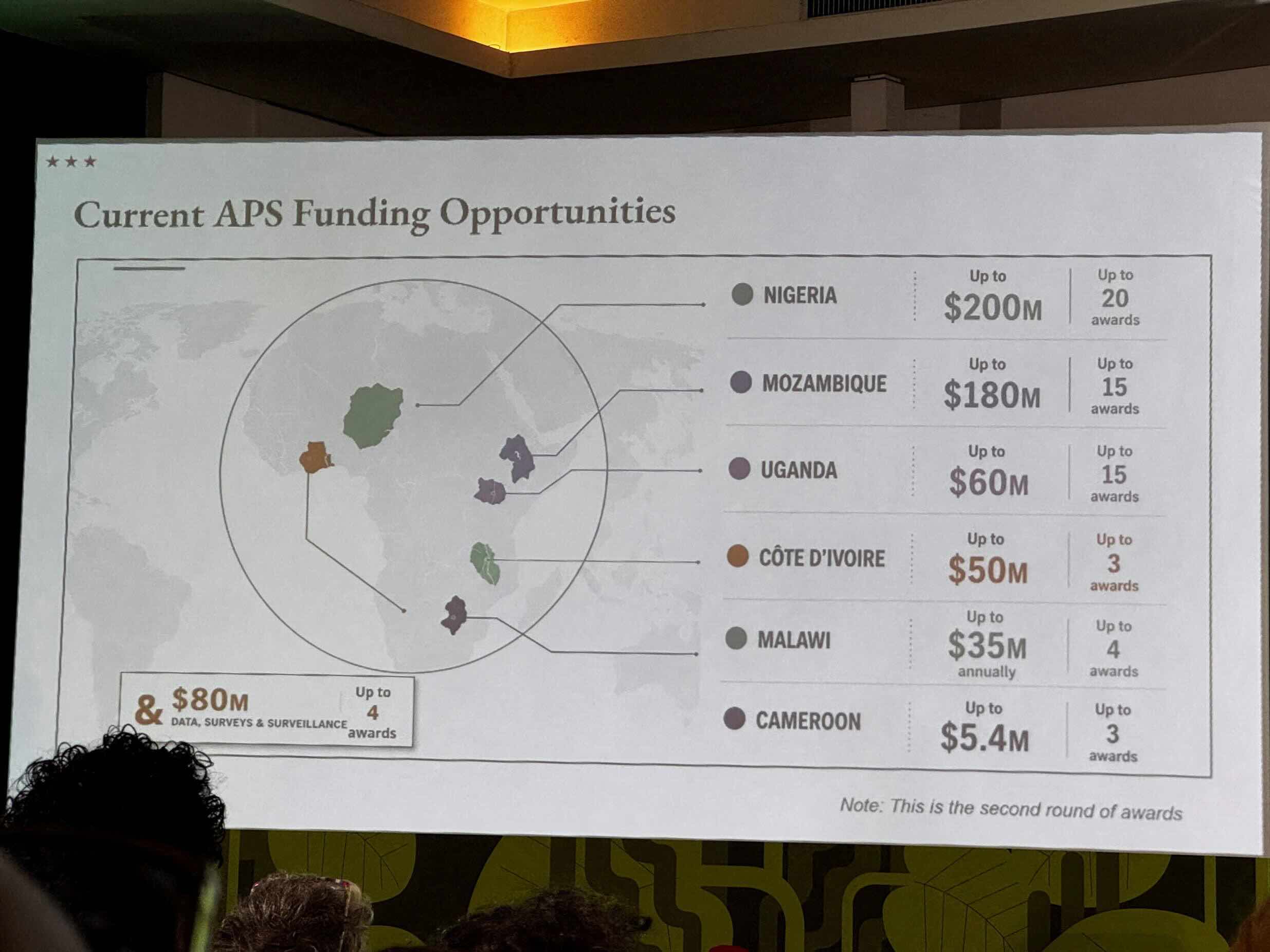
Photo: Reuters
The U.S. State Department, the very agency responsible for managing America's international relations and diplomatic presence abroad, committed an astonishing geographical blunder at a global health conference in Rio de Janeiro this week. During a critical presentation on PEPFAR — the President's Emergency Plan for AIDS Relief — the department displayed a map of Africa highlighting six countries. Every single one was wrong.
The map, which appeared on a slide during a presentation by Jeff Graham, the top U.S. health envoy overseeing PEPFAR, showed Nigeria as a landlocked nation stranded in the middle of the Sahara Desert. Mozambique, which sits on the southeastern coast of Africa, was relocated thousands of miles north to the Horn of Africa near Ethiopia. Côte d'Ivoire was placed on the completely opposite side of the continent from where it actually exists. Uganda, Malawi, and Cameroon were similarly misplaced, with their borders drawn as unrecognizable "blobs" that bore no resemblance to real-world geography.
The blunder was immediately noticed by attendees at the AIDS 2026 conference, who captured screenshots that quickly went viral across social media platforms. The embarrassment was compounded when a Reuters analysis revealed that the image contained an artificial intelligence watermark, indicating it had been generated using unverified AI tools from OpenAI rather than downloaded from standard, factually accurate sources.
The Cost of Cutting Diplomatic Expertise
The incident has sparked sharp bipartisan backlash, with critics and former diplomats pointing to a deeper systemic rot within the State Department. The official responsible for the presentation was a career employee, not a political appointee. But foreign policy experts argue the error is symptomatic of severe understaffing and a breakdown in quality control that has plagued the department in recent years.
Former State Department Africa official Cameron Hudson captured the sentiment on social media, writing: "There's a real cost in reputation and effectiveness" when expert staff are cut. His comments referenced the Trump administration's restructuring efforts, which reportedly included firing approximately one-third of the State Department's workforce and eliminating entire layers of bureaucratic oversight. The result, critics say, is a department where overworked junior staff lack the supervision and institutional knowledge necessary to catch foundational errors.
- Nigeria: Shown as completely landlocked in the Sahara Desert instead of on the western coast
- Mozambique: Relocated from southeastern Africa to the Horn of Africa near Ethiopia
- Côte d'Ivoire: Placed on the entirely wrong side of the continent
- Cameroon: Name printed on the slide but floating over the wrong area with no geographic marker
- Uganda and Malawi: Their national borders were drawn as unrecognizable, distorted shapes
The State Department formally apologized, calling it an "unfortunate error." A spokesperson explained that a staff member had "hastily altered" the slide deck immediately before the presentation and took full responsibility for the misrepresentation. But the explanation did little to quell the outrage, particularly because the presentation skipped the strict multi-checkpoint review process that normally clears government materials.
The AI Factor: Why Africa is a "Data Desert"
The reliance on AI-generated imagery has drawn particular scrutiny. Generative AI models are notoriously biased toward data from Western sources, creating what experts call a "digital data gap" for Africa. Because image generators are trained on billions of images scraped from the internet — the vast majority of which come from North America and Europe — they struggle to accurately render African geography.
AI image models don't actually 'know' geography. They treat images as pixels, textures, and patterns rather than factual data. When forced to draw Africa, the AI hallucinates — creating a visual aesthetic that prioritizes looking like a map over being accurate. This explains why the AI-generated map featured a nameless territory with a geographic marker but no corresponding country name — the AI was simply mimicking the appearance of a generic map placeholder.
By contrast, Europe is much harder for AI to get wrong. The continent benefits from massive data abundance: vastly more digital maps, travel images, and historical graphics exist online. Europe's distinctive coastal shapes — the boot of Italy, the Iberian Peninsula, the outline of the United Kingdom — provide strong visual anchors for pattern-recognition algorithms. Africa's borders, many of which are straight geometric lines drawn during colonization, lack these distinctive natural features, making them harder for AI to differentiate.
Geopolitical Fallout and Diplomatic Repercussions
The timing of the blunder could hardly have been worse. The U.S. had recently paused and scaled back some global health funding, and African leaders and health experts viewed the careless map as a sign of disrespect. Kenneth Ngure, president-elect of the International AIDS Society, called the incident "disheartening" and emphasized that "African countries must be taken seriously."
Senator Jeanne Shaheen publicly called the blunder an "embarrassment," stating bluntly: "This is what happens when [the State Department] fires career experts and tries to have AI conduct diplomacy." The sentiment reflects a growing concern that America's diplomatic credibility is being undermined by austerity measures and technological shortcuts that prioritize speed over accuracy.
The State Department has since announced it is reviewing its protocols for using AI-generated content in official presentations. But the damage may already be done. In an era where the U.S. is competing for influence in Africa against rising powers like China and Russia, such a fundamental failure of geographic literacy sends a damaging signal about the seriousness with which America approaches its relationships on the continent.
For an agency whose job is international relations, getting the map of Africa catastrophically wrong is more than just an embarrassing gaffe — it is a profound failure of the basic competence required to conduct diplomacy in the 21st century.
No Ads. By Us. For Us.
This article was made possible by readers like you. We hope it inspired you to support Emerald Book, so we can continue producing content like this.
We will never show you ads, sell your data, or require a subscription to consume our content. Your gift helps us keep the truth accessible.
Click the Support button to give a gift of any amount today.
Thank you for making this work possible.